The Road Journey
The road journey
from Srinagar to Leh takes two days to cover the 434 km distance with an
overnight halt at Kargil. Traversing the most fabulous terrain of incredible
heights and scenic mountain beauty, driving along the high mountain roads
is the most advisable way to travel to Ladakh. While an Indian Airlines
Boeing completes the trip in a mere 35 minutes, a road journey enhances
a traveller's experience by giving him ample time to acclimatise to the
unique climate of a plateau two miles high in the sky. It would he advisable
to travel in a jeep or car/taxi which gives greater freedom to stop enroute
at places of interest.
From Sonamarg in Kashmir, the road climbs towards
Zojila, some 25 km away at a height of 11,500 feet. Zojila is historically
of great interest since tanks for a major battle were used here at such
a height for the first time, in 1948. The pass at Zojila marks dramatically
the boundary line between Kashmir and Lardakh. Dense green forest clad
slopes give way tobare.multi-coloured mountains of stark beauty. Even the
air is colder, dryer and purer through percetibly lower in oxygen content.
The intensity of light doubles while the sky becomes an incredible blue.
From Zojila the road descends to the flowering
meadow of Minamarg a botanist's paradise, abounding in a wealth of exotic
alpine flora. Matyan, on the other end of the meadow, leads to Dras,
where temperatures drop to below minus 50°C. Enormous snowfalls and
severe winds during winters completely immobilise its inhabitants. Ethnically
a Dard settlement, the populace practices Islam.
Along the Dras river, passing Kaksar, one moves
towards Kargil, the journey showing remarkable evidence of indigenous engineering
- water channels cut deep into the granite slopes, rising terraces of carefully
nurtured soil preciously preserved between vertical walls of rocks and
boulders, several plantations and green fields at Channi Gund and Kirkit
Chu with groves of poplar, willow, apple and apricot orchards, barley and
buckwheat fields, all lending an air of serenity to the area.
Situated on the bank of river Suru at a height
of 9,000 feet, midway between Srinagar and Leh, Kargil provides an overnight
stop. The second largest town, it is an important junction of the historic
routes leading to Kashmir, Baltistan, Afghanistan, Central Asia, Sinkiang,
Tibet and via Zanskar to Jammu and Himachal. It was and continues to be
an important trade and tourism centre. All treks to Zanskar, Himachal,
Jammu and the Indus valley, as well as mountaineering expeditions to Nun
and Kun (twin peaks at a height of over 7,000 metres) begin from Kargil.
Climatically, Kargil enjoys a distinct advantage
over the rest of Ladakh. Food, fruits, fuel and timber are more easily
available with two crops being harvested every year.
Kargil retains the characteristics of a medieval
town with narrow alleys cobbled streets and curios right out of the Arabian
Nights. A predominantly Balti Shia Muslim settlement, the two mosques here
are superb examples of Turkish architecture.
Zanskar - Passing up the Suru valley through
Pensi La (which is open for 3-4 months: July-October), one arrives in Zanskar.
Twice a week bus services link Kargil with Padam in Zanskar. For the price
of a bus ticket one can also take a ride on cargo trucks on other days.
Over Pensi La is the 5,000 sq km vast expanse of concentrated mountains
and long valleys of Zanskar, an ancient kingdom with a better preserved
cultural entity. Primarily Buddhist, Padam is a sub-district headquarters
with several accessible monasteries and 8th century rock edicts with significant
carvings and inscriptions. Other places of interest in Zanskar are Karsha
with its large and wealthy monastery and Zangla. Treks commence from here
for Lamayuru and Hemis. Nothing can beat the excitement of a walk down
the rope suspension bridge at Zangla, while Phugtal and Zongkhul are two
famous cave monasteries in Zanskar. To savour a typical experience of western
Ladakh, a trip to Sanku, Panikhar and Parkachik is a must.
Leaving Kargil, crossing the Suru river, one climhs
a high, flat plateau to descend to Pashkyum, a verdant meadow and wealthy
village in the Wakha Rong valley. From here the next important habitation
is the fertile valley at Mulbekh with its high monastery perched on a rock.
From Wakha a 13,000 feet climb to Namik La (pillar in the sky) begins.
A beautiful chocolate brown landscape of rounded hills and snow sculpted
rocks gives way to the Budhkharbu valley leading to Photu La, another 13,000
feet high pass. A tantalising glimpse of the mysterious monastery of Lamayuru,
set amidst the grandest mountain scape of a drained lake invites the traveller
to examine it closely. Resuming the journey, the traveller descends to
the Indus valley at Khalsi over a series of long loops. Here one can see
the fantastic panorama of the Ladakh range: grey to chocolate, yellow to
russet, and brown to green, all a vivid contrast of highs and lows.
Downstream from Khalsi is the road to Batalik
through the Drogpa area of Hanuthang, Garkhun Da, Da Hanu and Darchick.
Upriver from Khalsi, the road travels along the river Indus right up to Leh.
Saspol, with its caves, and the Alchi monastery, lead the way to the
Likir monastery, finally descending to the fortress of Basgo, the Chargyal
Thang plain with its enormously large chortens, mane walls and the village
of Nimu.
From Nimu, the road again climbs to yet another
bare plateau, where you get the first glimpse of Leh, 30 km away. 15 km
short of Leh is Phyang and then comes the Spituk monastery from where the
Tsemo Namgyal peak, the fort, palace and gompa can be seen clearly, presiding
over Leh, guarding the route to Khardungla and dominating the Indus valley.
You arrive at last, at the most exciting destination, to view a millenia
old civilization, the culmination of the mingling of the culture, religion
and commerce of high Asia.
Leh - amidst starkly beautiful and majestic
mountains, gradually merging into an oasis of green fields, Leh is situated,
on the banks of the Indus, at a height of 11,000 feet. For seven months
a year, Leh airport is Ladakh's only link with the outside world.
Transport, tour operators, boarding and lodging
facilities are available to suit every pocket and there is sufficient novelty,
antiquity, hospitality and bargains to satisfy the quest of all types of
visitors.
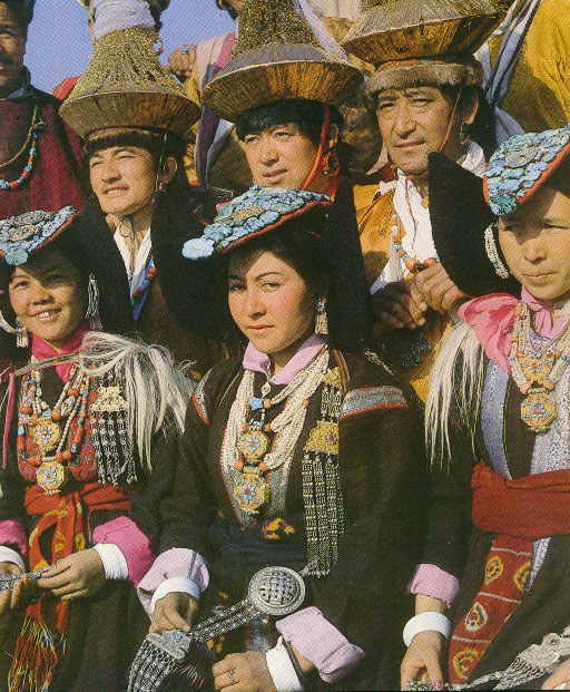
With a population of 10,000 people, mainly Buddhist,
some Argoos (Muslim descendants of Yarkandi traders) and a small Christian
community, Leh bears the distinct stamp of its history as the administrative,
commercial and cultural capital of Ladakh. A memorable sight of the Leh
bazar is the group of women, traditionally attired, selling fruits,
vegetables and household articles spinning and knitting, and exchanging
gentle banter between themselves and with passersby.
The mosque, city palace, the bazar and the gompas
are all within walking distance. Shey, Spituk and Phyang are quite close
while Stok, Mashro, Thikse, Stakna, Chenlrey, Hemis, Likir, Basgo and Alchi
are all a day's touring distance with regular bus and taxi services plying
daily. Rumbak and Markha offer exciting treks, while Stok Kangri is the
best for a climb. Boating and river running too is possible on the Indus.
|