Puranic Concept of
Mountains of Kashmir
By M.M. Munshi
Puranas cover a period of more than a millennium
starting from about the time of the coming into power in
India of the
Shunga Dynasty to the time of invasion of
North India
by Gaznavi. It was a chequered period of our history; great warriors, powerful
monarchs , brilliant outputs in art and literature, but unfortunately combined
with unhealthy growth of blind superstitions and the decay and death of spirit
of adventure in science ,thought as well as in practical life. In spite of
modern researches , we have yet to learn about the essential facts of those days
and among these facts are many which are related to geography. Indias’s
association and communication of those days was not confined to the narrow
parochial limits of the subcontinent, but extended to at least to a superficial
knowledge of a large part of the then known world as in the reference to Nile
river and its source in one of the Puranas The orthodox Pandits who
usually swear by Puranas or Shastras know very little about their
contents or meanings. Their rhetorical knowledge does not enable them to
identify the most of the rivers or mountains or other features to which these
words refer.
Vayu
and
Nilamata puranas form the basis of this write up together with Ksemndra’s
Samayasmidrika, Bilhana's Vikramankodevarosa and Stein's
interpretation of Ancient geography of Kashmir based on Kalhana;s
Rajtarangini. Vayu Purana contains the geographical data described in all
the Puranas and in certain cases gives more details including those on
Kashmir, Nilamata purana which deals primarily with
Kashmir
and other texts were selected as those give information not contained in the
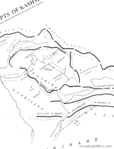
puranas. Approching Jammu & Kashmir from the plains of Punjab we come to the
lesser
Himalayas referred as Bahirgiri in
Nilamata and literature include
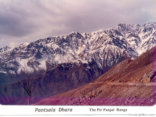
Pir Panjal
Range, and its south westerly spurs ,west ward extensions of Dhauladhar, namely
Jugdhar, Ladadhar, Trisuldhar,
Mundidhar Trikuta hills etc and foothills including Siwalik Range which has been
mentioned as Upagiri in Mahabharta Chula Himavanta in Pali and
Astadhyayi. Usiraka in Dharva(hilly area between Vitasta (Jhelum)
and Chandrabhaga. (Chenab) is most probably Kalidhar and its
eastward extension . Usiradhavaja of Vinaya texts, Usiragiri of
Divyavadana and Usinaragiri of the Kathasaritsagara have been identified
as designations of the same hills i.e Siwaliks in Darva and Madra
(area east of Chandrabhaga) by B.C.Lal There is no specific or direct
mention of Pirpanjal Range which forms watershed between Kasmira in the
north and Darva and Madra in the south in Nitamatha.But
peaks of Bahmasakli or Brahmasaki of the Pir panjal Range where Visnu,
Brhama and Maheshvara took their positions and Kramasaras (Konsarnag)
have been mentioned in the legend pertaining to draining of Satisar and killing
of the demon Jalodbava.Mention has also been made of the westernmost peak
Naubandana. At the end of the Manvantara Mashevara (Shiva) transforms
himself into water and turns the whole world into an ocean, Parvati assumes the
form of a boat and the future Manu puts all the seeds in that boat. After
assuming the form of a fish Vishnu pushes the boat and ties it to the high peak
protruding above the water and hence the name Naubandana. However
Pantsaladhara mentioned by Ksemndra has been identified as
Pir Panjal
Range.
The northern limit of the
Kashmir
valley is marked by the
Great
Himalaya Range refered in puranas as Antargiri and in the Pali literature
as Maha Hemavanta. A number of southerly and southwesterly ridges/ spurs
radiate from the central range giving rise to a number of side valleys .The most
prominent ridge Saskach (Sasakot) bifurcates from the great Himalaya
range near Mushran upstream of Amarnathji cave shrine forms a water parting
between Sind and and Lidar rivers. The Saskach follows a south-west
north-east trend and at Drunnar or Hangsatu immediately below Sonamarg is
traversed by the Sind river forming a narrow gorge beyond which it was known as
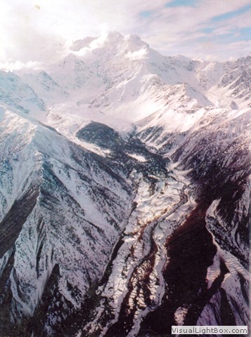
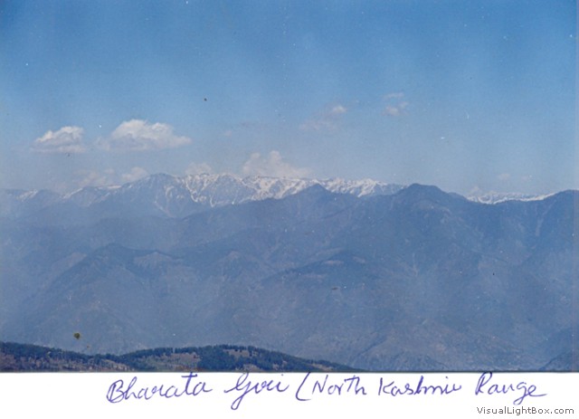
Bharatagiri (north Kashmir or Sogput Range) isolating the Krshna (Kishenganga)
valley from Sind and main Kashmir valley. Part of the same spur forming a
triangular mass of mountains bound on the north and east by Sindu (Sind )valiey
and south and west by Lidari (Lidar) valley and the main Kashmir valley extends
as far west as Bastavalika or Jeyarudasaras (Dai lake) and
Ganderbal has no modern name but was known in Puranic times as Mahadevagiri
and at a latter date as Dudvana. Lakes of Manasaras (Marsar)
and Tarasaras(Tarsar) and shrines of Hareshvara (Hareshor) and
Mahadeva are located on the triangular mass. The southern flanks of Dadvana
are capped by peaks of Dhanada and Vasrvana (Vastarvan.)A minor spur of
Mahadevagiri immediately south of Dal lake and north of
Jhelum
and west of Zabarwan known at present as Shankracharia hill was known as
Jyesthatudraparvata or Gopadri. The original temple is believed to
have been built by Jaluka son of Ashoka. The isolated hill of Hariparbat was
known by the name of Harparvata and Sarikaparvata.
To the east of
Dudukant
Pass and north of Lar pargana on the north
Kashmir
range rising to about 16,000 feet stands the Harmukuta Shiva's diade
popularly known as Harmukh. The lake which is at the foot of the glacier at an
elevation of about 13,000 ft. is the glacier fed Kashmir Ganga, Utraganga
or Utrasaras at present called as Gangabal.
According to Matsya Purana Aruna
mountains lie to west of Kailasa, and according to Vayupurana
on the other side of Kailasa and contains hundreds of peaks and is
dominated on the south by Dhumralohita -the king of mountains.
Lake
Silodaya
lies at its foot from which a river rises and flows west. The mountain to west
of Kailasa with hundreds of peaks is apparently Ladakh Range This is the
Aruna range of puranas. And Dhumralohita which lies south of and
near Aruna is the Nanga Parbat and its significance as king of mountains
can be visualized by the fact that summit of Nanga Parbat is 26,620 ft above msl
with its base at the side of Indus is 3500 ft. exposing a fall of 23,120 ft. to
an observer at its foot on the riverbed or on one of the passes connecting
Kishenganga valley with that of Indus valley.The un paralled view is much more
impressive than that of Namchebarwa Peak and bed of Tsangpo (Brahamputra) in
eastern Tibet. Lake Sailodaya appears to be Mahapadamsaras (Wular Lake) which
once covered whole of Kasmira (Kashmir Valley) as Satisar and river Siloda which
still flows through it is the Vitasta (Jhelum).The fall of more than 23,000 ft
exposed to the gaze of observers during the Purana Times led to the belief that
Dhumralohita (Nanga Parbat) was the highest peak in the world.
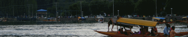
Source: Kashmir
Sentinel
Image Gallery
|