The Lost River
Sarasvati
By M.M. Munshi
A mbitame, Devitame,
Naditame Sarasvati
O best of mothers,
O best of Goddesses ,
O best of rivers.
Sarasvati do not kick us away,
do not let us go away from you to distant lands
was eulogised in the Rig Veda. The impetuous Sarasvati is rich for magnificent cows, excellent horses, good chariots, beautiful garments and abundance of gold. Such was the prominence in which Sarasvati river was held during the vedic times even greater than that of Ganga (Ganges and Sindu (lndus) and other rivers. The mythology and history of Sarasvati is very interesting. The withdrawal of waters of Yamuna sometimes between Vedic times and epic of Mahabarta and (ii) Satadru (Satluj) sometimes during the eleventh century dried up Sarasvati which was once a mighty river flowing from Himalayas to Rann of Kutch quite independent of the Indus and Ganges river systems was reduced to a legend. Today it is still believed by many that Sarasvati follows an underground course and joins Ganges along with Yamuna at Triveni. The quest for the lost river began about a hundred years back when a British engineer C.F Oldham while riding across the broad dry bed of a small stream called Ghaggar visualised that a 3 km wide river bed could not have been made by a puny seasonal stream like Ghaggar but must have been the course of a bigger river in the past.
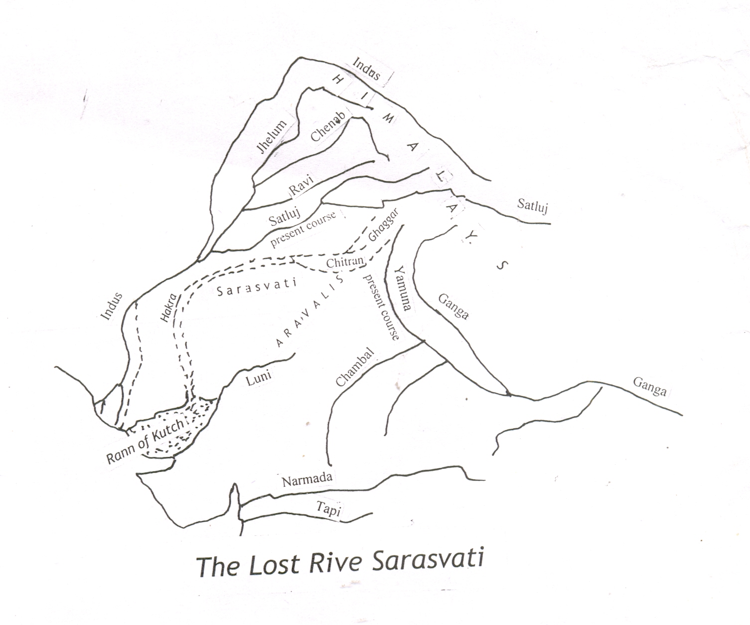
In the area between Indus and
Ganges river systems or to be
precise between the present
courses of Yamuna and Satluj
couple of seasonal dry channels
flowing in westerly and southwesterly
directions along very
broad dry river beds namely
Ghaggar and Sirsa met at Rasula
near Patiala and further downstream
near Bathnair near
Bikaner in Rajasthan are joined
by another dry seasonal channel
called Chitrang which can be
traced upstream eastwards up to
Yamuna is most likely the old
abandoned course of Yamuna
Upstream of Bhatnair and
downstream of Karnal the
Ghaggar is joined by another
buried channel (dry river course)
known at present as Wah,
Sirhind or Wahind which can be
traced upstream as far as Ropar
where Satluj emerges from the
from the hills after traversing the
Himalayas. This was the original
course of the Satluj before it
changed its course to join the
Bipasa (Beas ) of the Indus system.
A few more dried up channels
north of Sirhind Channel
called nahiwals have also been
traced up to Ropar. In Bikaner
and further downstream for a
length of about 150 km the
course of the channel is known
as Sotur or Hakra where it has
attained a widith of about 5 to 8
km. At places the course of the
river is still called Sarasvati by
the locals. Further downstream
the river course can be easily
traced around Mirgarh, Dilawar
in Bhawalpur and eastern Sind
in Pakistan ,southern Rajasthan
into Rann of Kutch through
Gujarat quite distinct from the
abandoned eastern channels of
Indus delta.
Along the course of this buried
channel 175 of pre and early
historic archeological sites have
been excavated and confirmed by
archeologists while only 85 of
similar sites have been located
along Indus in Pakistan. These
sites have revealed dwelling
sites, potsheds and other
Mohonjodaro and Harrapan
types of objects /artifacts. Recent
excavations at Dholsvaria
and other places have revealed
figures of ocean going vessels
providing clues to the navigability
of the dried up river. lt has
been universally accepted that
earliest settlements in the Indian
subcontinent and elsewhere the
major river valleys and not along
dry river beds/abandoned river
courses or uplands. How pre or
early historic settlements especially
with riverine culture could
have come up on the sides of
buried channels , unless major
rivers flowing along in the past.
On the basis of these findings
some experts have argued that
the Indus valley civilization
should be renamed as Sarasvati
Civilisation
Historical evidences also suggest
Bhawalpur in Pakistan, and
Bikaner in Rajasthan continued
to be well watered at the time of
Alexander’s invasion in 3rd century
BC and even as late in 9th
century AD. The Rann of Kutch
was a fairly deep inland sea and
ships and dhows of Arabs
moved along the then existing
river to Sind. Todd in his book
“Annals of Rajasthan" has
stated that Hakra in Bikaner became
dry in 11th Century AD.
Historical sources of Greeks and
Arabs indicate that Satluj was
not a Punjab river till 11th century
after which it abandoned its
course and joined the Beas.. Below
its present confluence with
Satluj it is still called Beas though
Satluj is larger of the two rivers.
The existence of a 1600 km. long dry river bed/buried channel / paleo channel varying in width from 3 to 12 km extending from Sirmoor Hills in Himachal Pradesh to Rann of Kutch has been confirmed by the study of both black and white and coloured satellite imageries by experts including Bimal Ghosh, Amal Kar, and scientists of Central Arid Zone Research Institute, P.S. Thakkar of ISRO and others that Paleo Channels extending from the present trijunction of Himachal Pradesh, Punjab and Haryana through Patiala, Karnal, Bhawalpur, Bikaner, south Rajasthan. Sind to Rann of Kutch in Gujarat is the dried course of once mighty Sarasvati River quite distinct from the Indus river system.
Sarasvati River deprived of its water by diversion of Yamuna to Ganges System sometime between Vedic age and epic of Mahabharta and Satluj to Indus System much later due to neotectonic moments along the axis of Aravali range was reduced to a dry river bed of several km in width. Having lost its snow fed sources the mighty Sarasvati river disappeared and only legend remained in the folklore.
The inhabitants from its banks migrated to far off places like Kashmir, western Punjab, Rajasthan, Gujarat, Maharashtra, Karnataka and even as far south as Kerala along the west coast some of whom still call themselves as Saraswat Brahmans or simply Saraswatas. In mythology the prominence of Sarasvati was taken over by Ganga A Kashmiri Pandit writer in one of his articles “ Kashmiriyat:
An Evolving concept”
published in July 2004
issue of Koshur Samachar has surmised that River Sarasvati was fed mainly by the outflow of water from the southeastern corner of Satisar (Pleistocene lake covering the entire valley). Due to development of a cleft on Baramula side Satisar was practically drained of its waters deprived Sarasvati of its feeder which ultimately resulted in drying up of the mighty river. The said concept is not feasible as waters of Satisar could not have flowed underneath across four major rivers namely, Chandar Bhaga
( Chenab),
Irvati (Rawi), Bipasa (Beas)
and
Satadru (Satluj)
before
meeting Sarasvati. Secondly the desiccation of Satisar and drying of Saraswati were not simultaneous events but as already indicated separated by a period about 10 to 12 millenniums.
Source: Kashmir
Sentinel
|