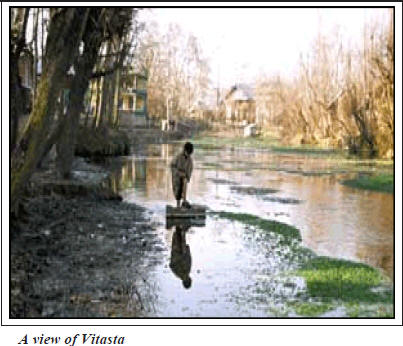
Vitasta
By M.M. Munshi
According to Nilmata
Purana it was Sati, daughter of Himalparvata consort of Shiva who was called uma
in Vaisvara Anatra is the same goddess as Vitasta and the same is Kasmira. The
Goddess Vitasta is verily the holy river, remover of all sins. People who offer
their bodies to, or die with its water in their bellies reach heaven without any
hindrance. Those persons who take bath in Vitasta do not see even in dreams
tortures of hell. Vitasta gives protection with her hands to the evil doing
sinners falling into the Hell. Fire of the hell for the sinners is pacified with
the cool outpourings of water drops sent from the waves of Vitasta carried by
the wind. A person by merely listening to the glory of Vitasta goes free from
sins. The only thing that Ganga has more than that of Vitasta are the heaps of
bones of human beings, all others things are equal.
The river draining the
entire Kashmir Valley called by the Kashmiri as “Vyath” is the direct derivative
of the original Sanskrit name Vitasta. The Intermediary Prakrit form Vidasta was
altered by Greeks to Hydaspes. Vitasta is also mentioned in the river names of
Rigveda. In Vayupurana Vitasta has been referred as Biloda and the Wular lake as
Bilodia situated south of Dharma Lohita (Nanga Parbat) - the King of mountains.
The modern name of the river Jhelum has been adopted from the city of Jhelum
besides which it flows in Pakistan. The name was brought to Kashmir by European
travelers and found its way into official usage, otherwise the river is still
known to the natives as Vyath.
The River Vitasta can be
considered to have formed at the confluence of (i) Harsptha (Arapat) from the
north east, (ii) Bringha (Bring) and (iii) Sandran [older name not known] from
the south east meet each other near Anantnag. But the old holy scriptures have
traced the origin of Vitasta to a more specific source. As already stated in
Nilmatapurana, Harcar-itacintamani and subsequently quoted in historical books
Vitasta is a manifestation of Goddess Parvati.
After Satisar [Parvati’s
lake] Kasmira was drained of its waters and demon Jalodbhava destroyed by
Vishnu, Brahma and Mahesvara. At the request of Sage Kasyapa (Kashap Rishi),
Mahesvara persuaded Parvati to show herself in Kasmira in the form of river to
purify the humans from the unholy contact of Pisachas. The Goddess assumed the
form of an underground river and asked Shiva to make an opening by which it
could come to the surface. This was done by Shiva by striking the ground with
his Trisul on 13th of Bhadra Shakula Paksha from which the river gushed forth
receiving the name Vitasta after the measure of the ditch of one Vitastati.
Since then the birthday of Vitasta is celebrated on 13th of Bhadra Shukla Pakash
every year. The spring from the where the goddess flowed in river form became
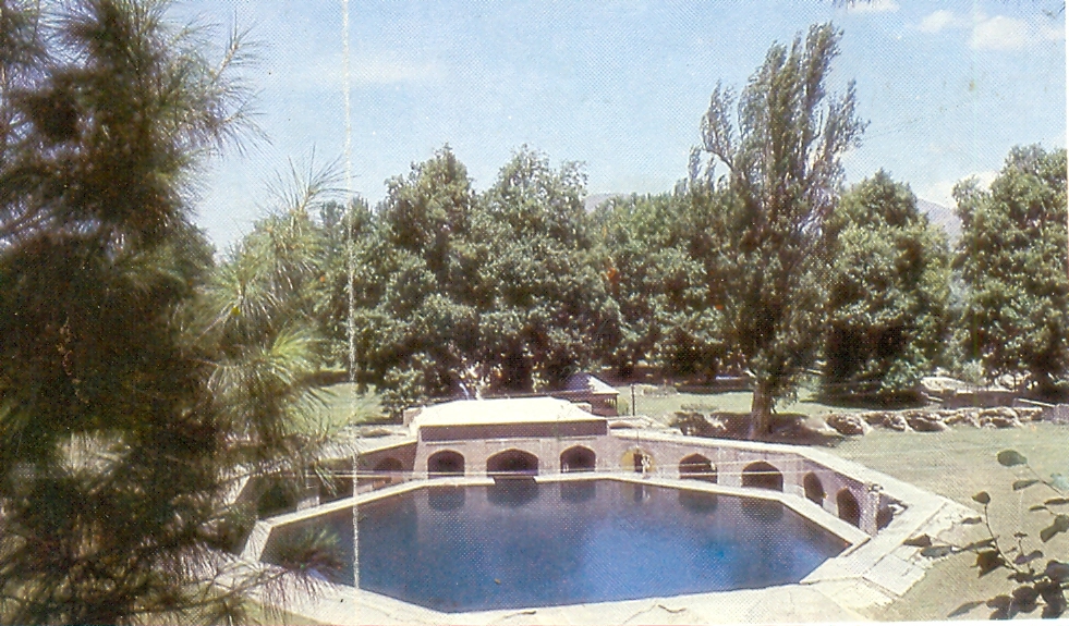
known by several names Nilanaga [abode of Nila], Nilakunda, Sulaghata (Trishul
Thrust) or simply Vitasta. The name of Var or Verinag seems to have been
adapted- at a later date probably after the administrative unit of Var Pargana.
It is said that Vitasta
disappeared from fear of defilement from the contact of sinful-men but
reappeared second time by the prayer of Kasyapa at Panchasta (Panzath) in Devsar.
Vitasta disappeared again and reappeared at Narasima. The Goddess was finally
induced to stay permanently when Kasyapa had secured her the company of Lakshmi
in the form of Visoka (Vesheu) and Ganga in the form of Sindu (Sind river) {not
to be confused with Indus}. Sachi consort of Indra as Haraspatha (Arpath), Aditi
the mother of Gods as Trikothi, (Probably Sandran?) and Ditti mother of Daityas
as Chandravati (Probably Bring?) According to another legend Vitasta made her
second appearance at Vitastatra (Vethvutur) close to Verinag. Clear mention of
Nilanaga as the birthplace of Vitasta by Kalhana about its source leaves no
doubt about the tradition prevailing in his time. The Bringa (Bring) rivulet is
fed by springs of Trisandya, Ardanarisvsra, Kaptesvara (Kother). Akasvala (Achibal)
feed the Harspatha (Arapath) rivulet. Lidari (Lidar) which derives its waters
from the glaciers of Koenjnar and Gashbrar (Kolahi), lakes of Shushramnaga (Sheshnag),
and Tarsar, springs of Nil ganga, Mamleshwar, Machbawan (Matan) and other
streams joins the Vitasta a few kilometers downstream of Anantnag.
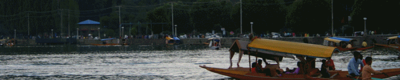
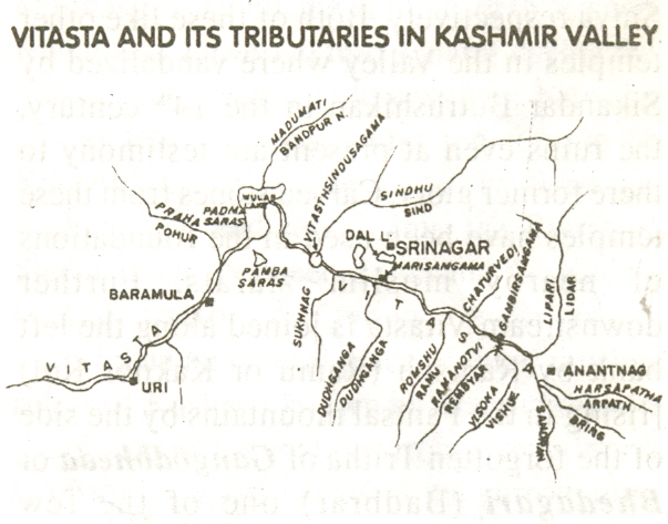
Vitasta becomes navigable
at Anantnag and flows in a single channel except in the city of Srinagar. In its
north-westerly course between Anantnag and Baramulla a direct distance of about
90 Kms the river bed falls slightly less than 75 meters in elevation. Islands if
any are sandy and temporary except the one at the present Vitastasindhusamgama
near Shadipur which has been artificially built. The most conspicuous meander of
the river is located immediately south of Gopadri (Shankracharya hill) round the
flood prone locality of Shivpura.
The course of Vitasta
during the historic times has not changed except at the Vitastasindusamgama
where it was altered by Suyya, able engineer of King Avantivarman, between
Mahapadamsaras (Wular Lake) and Huskapara (Uskar) Vitasta flows in a south
westerly direction and beyond Uskar in a generally westerly direction upto
Muzafrabad Kohala area. At Wular and Muzafrabad Vitasta abruptly makes southerly
bends due to the syntaxial bend of the western Himalayas in common with other
rivers of the region.
Downstream of Anantnag on
the banks of Vitasta is located Vijayaksetra (modern Vijbror) one of the holiest
sites where temples of Shiva Vajesvara, Vishnuchakradara, Ashoksvara and
numerous viharas and agarharas and a university of learning, [where students -
scholars from countries beyond Kasmira used to come for the study of Shastras,
astronomy, astrology and other subjects] once flourished.
United waters of Visoka (Vesheu)
issuing from Kramasaras (Konsar Nag) also known as Vishnupad near the tirtha of
Naubandana where Vishnu, Brahma and Mahesevera took positions to destroy the
demon Jalodbava and (ii) Ramantavi (Rembyar) originating from Bagh and Nandan
Sars join the Vitasta along the left bank as Gambhira (deep) (Sardari Nala) at
Gambirasamgama (sangam) below Vijbror, where King Chandrapida built a Vishnu
temple of Gamirasvamin of which no trace is left at present. About few
kilometers downstream of Gambirasamgama King Avantivarman founded his capital on
the right bank of Vitasta at Avantipura during the 9th century and built two
temples, Avantisvamin and Avantisvara dedicated to Vishnu and Shiva
respectively. Both of these like other temples in the Valley were vandalized by
Sikandar Buthshikan in the 14th century, the ruins even at present are testimony
to their former glory. Carved stones from these temples have been used in the
foundations of nearby muslim ziarats. Further downstream Vitasta is joined along
the left , bank by Ramshu (Ramu or Kakpor Kol) [rising in the Pantsal mountains
by the side of the forgotten Tritha of Gangodbheda or Bhedagari (Badbrar) one of
the few Sarasvati’s temples of Kashmir] near the present village of Kakpor with
ruins of old Hindu temples. The ruins are believed by some authorities of the
time of King Khagendra the founder of Khagendrapura (Kakpor) by others as
remains of utplasvamin a Vishnu Temple built by Utpla an uncle of King
Cippatajayapida. In case the former identification is correct remains can be one
of the oldest in Kashmir, if the latter is correct these can be of 9th century
AD. Just opposite of Kakpor on the right bank of Vitasta stands the Saffron
Karewah and town of Lalitpur (Letpur) is said to have been founded by the
architect of Laltaditya. The Vishnu temple of Pandanasvamin was built by Padma
another uncle of King Cippatajayapida at Padmapura (Pampore) is now in ruins.
Another temple on the left bank of Vitasta opposite Panduchak a temple of
Samaravasmin was built by Samara a minister of King Avantivarman of which no
trace is seen now. Close to Panduchak is the Tritha of Tsakanga near Jeyyavana (Zewan)
which is visited by devotees even today.
Further downstream at
Pandrethan along the right ban of Vitasta aa temple of Merudasvamin built by
Merudana a minister of King Partha. It is believed that Srinagari capital of
Kasmira was founded by Ashoka at Pandrethan and present cantonment of Badamibagh.
When Pravarasena II shifted the capital to Pravapura [the high ground between
Harparvata (Hariprabat) and Kusurikabla the old capital near Pandrethan was
subsequently called Purandisthana. The ruins of other hindu temples around
Pandrethan were seen till the beginning of the 20th Century.
About two kilometers north
of Puranadisthana, is the hill of Gopadri also known as Jyestherudrakhyaparvata
(Shankracharya Hill) on which standas the temple of Jeyastherudra (Shankracharya
Temple) believed to have been originally built by Jaluka of which now the only
outer plinth remains. King Gopaditya rebuilt the temple at a latter date and
viharas at Guphara (Gupkar). The temple was repaired again during the region of
Zainulabdin the pious muslim king of Kashmir in 15th century and also by the
Dogra rulers during early 20th century. It is believed that the said temple was
connected by stone steps with Shurayar. The stone steps were removed and built
into Pathar masjid near Mujahid Manzil on the left bank of Vitasta by Noor Jehan.
River Vitasta is joined along its right bank by Mart or Mahasirat (Tsuntkol)
[Issuing from the Jeyarudrasaras (Dal Lake)] at Marisamgama which was considered
a holy Tirtha in ancient limes. The Island formed between Vitasta, Tsuntkol and
by latter’s southerly flowing branch was known by the name of Maksiavamin and
had a Vishnu Temple of the same name of which no trace is left today.
Opposite the Marisamgama
Kippitiska or Kutkulia (Kutkol) leaves the Vitasta and after flowing in a
northwesterly direction bifurcates into two, the easterly branch falls back into
Vitasta above Safakadal and the westerly branch joins Duddhaganga (Dudganga or
Chats Kol) which also falls into Vitasta near Chatabal. It is not clear if
Katkulia is a natural channel or a manmade one.
Below Marisamgama the
present Malyar ghat stood the temple of Vardamanesa of which nothing is left
today, a linga serving as a lamp post in a nearby mosque believed to be from the
original Vardmanesa temple was removed and installed in the present Malyar
temple in 1888.
Immediately below the
Habakadal on the right bank of Vitasta is the Somyar temple, site of the ancient
Somatirtha. Similarly situated on the left bank of the river is Purushyar the
site of ancient temple of Sadashiva. Between Haba and Fateh kadals at the
locality of Narparistan near Malikangan stood the temple of Narisheri which was
converted into a ziarat during the muslim rule. Further downstream between
Fatehkadal and Ziankadal the temple of Kalishiri which was destroyed by Sikandar
Buthushikan and rebuilt into a Ziarat between Zaina and Ali Kadals is the tomb
of Queen of Sikandar Buthshikan and burial place of other muslim rulers of
Kashmir known as Mazar’ salatin which due to its foundations from riverside and
the use of carved stones in the surrounding wall betrays it to be the site of an
ancient Hindu Temple. Again on the right bank almost touching the Alikadal
bridge is that ziarat of Wyusi Sahaib which also due to its foundations
embankments on the riverside and entrance appears to be site of an ancient
temple. Nothing is known at present about the antiquity of these two temple /
shrine sites.
Near Chatabal locality
confluence of Dudhaganga (Dudgangaor Chatkol) [issuing from Pantsal mountains)
with Vitasta was the site of tirtha known as Dudhagangasangma is now completely
forgotten. The other shrines/ temples along the banks of Vitasta within the city
of Srinagar city like Hanumanmandir, Gadadhar, Kharyar, Malyar, Raghunath
Temple, Batyar etc., are of recent construction during the Sikh and Dogra Rule.
However it is possible that some of these temples like Ganpatyar were rebuilt at
ancient temple sites. Between Srinagar and Shadipur the Vitasta is not joined
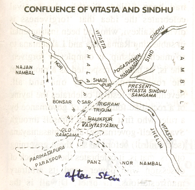
by any major tributary except the Sukhnag along the left bank. The Sindhu (Sind
River) [rising from the Great Himalaya Range south east of Amreshvara (Amarnathji
Cave) joined by glacier fed streams of Panjtarangini (Panjtarni) Amurveth (Amravat)
Nehnar etc., Outflows of the lakes of Utrasaras or Utraganga (Gangabal) Koladuka
(Nandkul), springs of Sodara (Narannag) uniting into Kanakavahini (Krenknadi)
stream flowing in Nandeksetra by the sides of Holy Harmukata (Haramukh)
Butheshvara, Jyethrudra, Ciramokana , at Kankanpura (Kangan) used to meet
Vitasta at Vitastasindhusagama till the 9th century immediately west of the gap
of BadrikhEL Nala between the Vudars (Karewas) of Parihaspura (Paraspur) and
Trigami (Trigom) close to former temples of Viushnusvamin and Vinayaswamin about
5 kms southwesT of the present confluence at Sundribhavana (Naranbagh) near
Shadipur.
Parihaspura (paraspur) was
founded by Laltaditya Mukhpida as his capital which according to Kalhana exelled
the heaven. Laltaditya whom Kalhana has called “Indra of the earth built
numerous other temples Parihaskesva with the image of Vishnu in silver and
pearls, Mukhtakesva with golden image of Vishnu, Mahavara with Vishnus image in
golden armour and silver image of Goverdandhara, Brhadbuddha numereous Viharas
and Agarharas and palaces.Even hisqueen Kamalavati built Kamalahatta with silver
image of Kamalakesva. One of Laltaditya’s ministers Mitrasarman an installed the
Shivlinga of Mitresvara. Needless to say that the site of the capital
Parihaspura and numerous temples was apparently chosen for its proximity to
Vitasta-Sindu-Samgama the former being regarded as manifestation of Jamuna and
latter that of Ganga.
Suyya the able engineer of
King Avantivarman by his skill shifted the position of Vitastasindisamama from
Parihaspura to its present location in the vicinity of Sundribhavana by forcing
the course of Vitasta north eastwards by construction of embankments to reclaim
cultivable land from flood prone areas and nambals (marshes). A Vishnu Temple by
the name of Yogavasmin was also built by Suyya at Sundribhavana at the instance
of King Avantivarman. The ruins of the said temple seemed to have been used to
built the solid masonary island [referred as Prayaga in the Vitasta mahatmaya]
at the present Vitastasindusamgama at a later date. Beyond the samgama, Vitasta
continues to flow northwestwards by the side of Vaskur village (Rupbhwani’s
shrine}, receives the outflow of Manasaras(Manasbal) at Sumbal and after passing
Jayapura (Indrkot) enters the Mahapadamsaras (Wular Lake). The ruins of ancient
temples and buildings town of Jayapura founded by King Jayapida on an island
like raised ground among the Nambals (marshes) north of Sumbal were seen upto
middle of 20th century. King Jayapida also built the castle of Bayakota on the
peninsula like ridge Davarvati with three images of Buddha, a vihara and shrine
of Jayadevi, According to Kalhana the castle of inner town excelled heaven in
beauty. Vitasta after entering the Maha Padamsaras from the east leaves it from
its southwestern corner near Suyyapura (Sopore). The site of
Mahapadamsaras was originally occupied by a wicked naga Sadangula who was exiled
by the naga king Nila to Darvisara. The site left dry was occupied by
a city called Chandrapura ruled by king Visvagavas, Mahapadmanaga is
disguise of a Brahman approached Visvagavas to reside in the city with his
family. After securing permission he showed himself in his true form with the
result king and his subjects had to migrate westwards to the new town of
Visvagasvapurata. A glance from high mound will show that a peninsula like ridge
projects into Mahapadma lake due to continuous disposition of silt of Vitasta,
in the long run well result in shallowing and shrinkage of the area of lake.
Similar silting though on a relatively small scale is going on the north side of
the lake due to Madumati stream (Bandipur nala). It can also be surmised from
the facts that the waters of Vitasta are muddy at its enterance into the lake
and clear at its outflow from the lake. It is also corroborated from the
evidence available from historical sources that man made island of Jainalanka (Zainnlank)
which according to Jonaraja was surrounded by waters and at present is
surrounded by marshes and land, the silting in Wular is not checked the great
and biggest lake in Kashmir will be reduced to a marsh [similar to like those of
Anchar, Hokarsar or Pambsar] with Vitasta slowly meandering through it. In case
the Wular has to be preserved for future generations an alternative channel for
Vitasta by passing the lake say between Sumbal and Baramulla through which the
waters, of Vitasta will have to be regulated by a barrage/vier during floods,
heavy rains or whenever the waters of Vitasta turn muddy. The site from
Madhumati (Bandipurnala) can be checked from entering Wular Lake by a cofferdam
and silts from which can be removed from time to time for building purposes.
Downstream of Suyyapura (Sopore) Vitasta receives in Kashmir its last tributary
of considerable size the Prahaa (Pohru) draining the north western corner of the
valley being of steeper gradient and faster current deposits silts in the
Vitastabed resulting in rise of the level of the Wular Lake. However from time
to time the silt at the confluence of Vitasta with Phara has been removed by
dredging. Vitasta after passing the last major town of the valley Baramula
enters its. mountainous course near Huskapura (Uskur) beyond which it is
unsuitable for navigation. The name Varahramula (Varmul or Baramula) has been
derived from the ancient Tirtha of Vishnu-Adi-Varaha where Vishnu was worshipped
since time immemorial as a medival boar. On the western extremity of the town
near Kothitirtha till very recently a number of ruins were seen but not much is
known about their antiquity.
Between Uskur and Uri
Vitasta flows in a south westerly direction and beyond in a somewhat in north
westerly direction upto Muzafrabad-Kohala [where it is joined by Mahasindu or
Krasna (Kishenganga) and Kunar or Kahgan rivers follows a southerly course upto
Mangla near Jhelum forming the boundary between State of Jammu and Kashmir and
Punjab Province of Pakistan. From Mangla onwards it flows in a south westerly
trend before joining Chandrabhaga (Chenab) near Jhang-Sadar in Pakistan.
Source: Kashmir
Sentinel
Image Gallery
|