Chapter 2
The Making of
Jammu & Kashmir StateAcquisition
of Kashmir valley by Gulab Singh in 1846 and its incorporation in his vast
Dogra Kingdom marked the beginning of a new and, from the point of view
of the present study, a crucial phase in the long and chequered history
of the land of Kashyap. The developments which have put Kashmir on the
map of the world as a storm centre are directly linked with the international
developments connected with the steady expansion of the British, the Russian
and the Chinese empires in the 19th century. With the annexation of Lahore
kingdom by the British which made the British Indian empire contiguous
to Afghanistan and push of Czarist Russia toward Hindu-Kush mountain. Jammu
and Kashmir state became the meeting ground of the three empires the British,
the Russian and the Chinese. The global interests of the British then demanded
that they should have a direct grip over J & K state. This impelled
them to put pressure on its Dogra rulers to make them amenable to their
game plan.
It is, therefore,
important to have a close look on the kingdom that Gulab Singh built, its
geographical position, demographic complexion and the place of vale of
Kashmir in it.
An objective
assesment of Gulab Singh who carved out for himself and his successors
a virtually independent kingdom of over 84,000 sq. miles stretching from
the pIains of Punjab to the Pamirs, Sinkiang and Tibet at a time when other
Indian kingdoms, some of which had a hoary past, were falling flat like
houses of cards before the fast moving British stream roller, is also relevant.
Born in 1792,
Gulab Singh was a scion of the ruling family of Jammu which was one of
the 22 petty Rajput states in which the sub-mountainous "Kandi" area to
the north of the Punjab was then divided. He left his home at the age of
seventeen in search of a soldierly fortune. He intended to go to Kabul
and join the army of Shah Shuja, but his companions refused to go beyond
the Indus. Then, he decided to join the service of Maharaja Ranjit Singh
who was at that time making his mark in the Punjab. He joined the army
of Ranjit Singh in 1809, the year in which the latter signed the famous
treaty of Amritsar with the British which gave him a free hand to expand
his kingdom to the West of the Sutlej.
Gulab Singh
soon distinguished himself as an intrepid soldier with a high sense of
duty and devotion to Ranjit Singh. He made his mark in many a campaign
which Ranjit Singh undertook to conquer Kangra, Multan and Hazara. He also
introduced his two younger brothers, Dhian Singh and Suchet Singh, in the
court of Ranjit Singh. Both of them later played a very important role
in the making and moulding of the kingdom of Lahore.
Ranjit Singh
rewarded Gulab Singh by appointing him Raja of his ancestral principality
of Jammu and put the "Tilak" on his forehead with his own hand in 1822.
Thus, after thirteen years of absence from Jammu, he returned to it as
its ruler under Maharaja Ranjit Singh. Having thus secured a foothold in
his ancestral home, he assiduously tried to extend his influence in the
surrounding areas while serving Ranjit Singh whenever and wherever required.
His interests at the court of the Lahore kingdom where well looked after
by his younger brother, Raja Dhian Singh, who rose to be its Prime Minister.
As Raja of
Jammu, Gulab Singh raised an army of his own which included such notable
soldiers as Wazir Zorawar Singh. He conquered the Principalities of Bhimber,
Rajouri, Bhadarwah and Kishtwar which extended the limits of his state
to Rawalpindi in the west and border of Laddakh in the north-east. The
valley of Kashmir which had been annexed by Ranjit Singh earlier was, however,
ruled by a separate governor as a province of the Lahore kingdom and Gulab
Singh had nothing to do with it.
In 1834, Gulab
Singh Decided to extend his sway to Laddakh and Baltistan. He entrusted
this job to Wazir Zorawar Singh who successfully led six expeditions into
Laddakh between 1834 and 1841. Since Kashmir valley was not under Gulab
Singh at that time, the route followed by Zorawar Singh was through Kishtwar,
Padar and Zanskar. It was more difficult but much shorter than the route
passing thrcugh Kashmir valley via Yojila pass.
After having
conquered and added the kingdoms of Baltistan and Laddakh to the territories
of Gulab Singh, Zorawar Singh decided to go forward and conquer Tibet.
It was a most adventurous move. He left Leh with an army of about 5000
Dogras and Laddakhis in May 1841 with a pledge not to return to Leh till
he had conquered Lhasa. After overcoming the Tibetan resistance at Rudok
and Tashigong, he reached Minsar near lake Mansarover and the holy Kailash
mountains. From there he advanced to Taklakot which was just about 15 miles
from the borders of Nepal and Kumaon and built a fort there. Here he met
two emissaries, one from the Maharaja of Nepal and the other from the British
Governor of U.P., then called North-West Province. The British were not
happy over Zorawar Singh's advance because they dreaded a direct link up
of Lahore kingdom with the kingdom of Nepal. They had in fact been putting
pressure on Lahore Darbar to press Gulab Singh to recall Zorawar Singh
and vacate the Tibetan territory already occupied by him. Zorawar Singh
was, however, blissfully ignorant of these moves. But an intense cold weather
and the long distance from his base at Leh forced him to stop further advance
and encamp at Taklakot for the winter.
In the meantime,
the Lhasa authorities sent large reinforcements to meet him. On learning
the approach of this new army from Lhasa, Zorawar Singh, intrepid and dashing
as he was, decided to take the offensive against the advancing army instead
of waiting for it to attack him. It was not a very correct decision. His
supply position had become extremely bad and his Dogra soldiers had been
reduced to sore straits by the intense cold. Many of them were frost-bitten
and incapable of moving about. As a result the battle of Toyu, which was
fought on the 11th and 12th December, 1841 at a height of about sixteen
thousand feet above sea level proved disastrous for Zorawar Singh who died
fighting. Dogra army like Napolean's army in Russia, was destroyed more
by cold then by the Tibetans.
The death of
Zorawar Singh was a grave blow to Gulab Singh's prestige in Laddakh where
people rose in rebellion aided and abetted by the advancing Tibetan army.
A new army was then sent from Jammu under the command of Dewan Hari Chand
which suppressed the rebellion and threw back the Tibetan army after inflicting
a crushing defeat on it which convincingly avenged the defeat of Toyu.
Thereupon the Tibetan Government approached for peace. A peace treaty was
signed on the 2nd of Asuj, 1389 Vikrami (September, 1842) by Diwan Hari
Chand and Wazir Ratnu on behalf of Gulab Singh and Kalon Surkhan and Depon
Pishy on behalf of Dalai Lama. By this treaty, the traditional boundary
between Laddakh and Tibet 'as recognized by both sides since olden times,'
was accepted as boundary between Jammu and Tibet. The village and area
around Minsar near Mansarover lake which was held by the Rajas of Laddakh
since 1583 was, however, retained by the Jammu government. The revenue
from Minsar which lies hundreds of miles inside Tibet was being received
by the Jammu and Kashmir Government regularly till 1948. This treaty of
1842 settled the boundary between Laddakh and Tibet in unequivocal terms
leaving no cause for any kind of border dispute in this region.
While Zorawar
Singh was making history in Laddakh and Tibet, the kingdom that Maharaja
Ranjit Singh had built had fallen on evil days. Ranjit Singh died in 1839.
His death was signal for the worst kind of anarchy and mutual killings
in the history of the Punjab. The Sikh nobles who had been jealous of the
ascendancy of the Dogra brothers in the Lahore Kingdom, now began to conspire
against them with the help of Sher Singh who succeeded to the gaddi of
Ranjit Singh after the death of Kharag Singh and his son Naunihal Singh
in rapid succession. The situation was made much more difficult by the
presence of British troops in Peshawar in terms of the Tripartite Treaty
of 1838 by which Ranjit Singh had agreed to help the British to put Shah
Shuja on the throne of Afghanistan. Gulab Singh was then at Peshawar to
assist the British on behalf of the Lahore Durbar. The Muslim battalions
of the Punjab army had refused to fight against the Muslim Afghans and
had mutinied. The party in power at the Lahore court was, if not actually
hostile, at least indifferent to the fate of the British troops still stranded
in Afghanistan. Gulab Singh well understood the situation and proved very
helpful to the British in terms of the Tripartite Treaty in getting them
out of a difficult situation. The British felt gratified and at one stage
actually proposed that he might be given possession of Peshawar and the
valley of Jalalabad in return for Laddakh for the timely help rendered
by him. But he refused the offer both on moral as well as practical grounds.
Laddakh had been conquered by him through his own army and was contiguous
to Jammu while Peshawar and Jalalabad would be too far removed from his
ancestral base at Jammu. But the assistance he rendered created a high
respect in the minds of the British for him and his Dogra army.
Things moved
rapidly in Lahore after 1841. Both Dhian Singh, the ablest leader and Prime
Minister of the Lahore Kingdom, and Suchet Singh were brutally murdered.
Maharaja Sher Singh too was murdered and the infant Dalip Singh was put
on the throne with a council of regency dominated by his mother Ranichand Kaur. Gulab Singh escaped because he kept away from Lahore most of the
time. These murders of his brothers naturally left him cold toward the
affairs of the Punjab and he began to concentrate on building his own power
in Jammu. He took no part in the first Anglo-Sikh war which began in 1845.
The Lahore Darbar wanted him to come down to Lahore and lead its armies.
Had he agreed, it would have made a world of difference for both sides.
His advice to the Council of Regency at Lahore to avoid war with the British
was not heeded.
After the defeat
of the Sikh army at Subraon in February 1846, peace negotiations were opened.
Raja Gulab Singh was given full powers to negotiate on behalf of the Lahore
Darbar. The British Government were well aware of the resourcefulness of
Gulab Singh who was reported to have advised the Lahore Darbar to avoid
pitched battles with the British and instead cross the Sutlej and attack
Delhi with the help of some picked cavalry regiments. The British were,
therefore, very anxious to secure his friendship. He was offered a bait
that he would be recognized as an independent ruler of Jammu & Kashmir
if he withdrew his support from the Lahore Darbar and made a separate deal
with the British. Gulab Singh replied that he could not negotiate with
the British about his own possessions while he was acting as an envoy for
Dalip Singh, the king of Lahore. He continued the negotiations on behalf
of the Lahore Darbar which culminated in the Treaty of Lahore signed on
9 March, 1846.
According to
this Treaty of Lahore it was agreed to by the Lahore Darbar to cede the
territory between the Beas and the Sutlej to the British and Pay 15 lakh
pounds (Rs. One Crore Nanak Shahi) as war indemnity. Lal Singh, the then
Prime Minister of the Lahore kingdom, had no love lost for Gulab Singh.
He offered to the British the hill territories of the Lahore Kingdom including
Jammu & Kashmir in lieu of the indemnity. His idea was "to deprive
Gulab Singh of his territory and give the British the option either of
holding Kashmir which would have been impossible at that time because of
the long distance and intervening independent State of Punjab or to accept
a reduced indemnity."2 This offer, however, suited Gulab Singh. The original
offer of making him an independent ruler of Jammu & Kashmir was revised.
But now it was conditioned by his taking the responsibility of paying the
indemnity which had been made a charge on this territory by the cleverness
of Lal Singh.
Gulab Singh
agreed to pay the money to the British and they recognized him as an independent
sovereign.
Accordingly,
a stipulation was made in the Treaty of Lahore by which Maharaja Dalip
Singh of Lahore agreed to 'recognize the independent sovereignty of Raja
Gulab Singh in such territories and districts in the hills as may be made
over to the said Raja Gulab Singh by a separate agreement between him and
the British Government.'
Seven days
later, on the sixteenth of March, 1846, the Treaty of Amritsar was signed
between Maharaja Gulab Singh and the British according to which Gulab Singh
was recognized as an independent ruler of all the territories already in
his possession together with the valley of Kashmir which until then formed
a separate province of the Lahore Kingdom.
According to
the Treaty of Amritsar, the British transferred for safe independent possession
to Maharaja Gulab Singh and his heirs all the hilly and mountainous portions
with its dependencies situated to the east of the river Indus and West
of the river Ravi including Chamba and excluding Lahaul - being part of
the territories ceded to the British Government by the Lahore Kingdom.
In consideration for this Maharaja Gulab Singh was to pay to the British Rs. 75 Lakhs in cash.
There was stipulation
in this Treaty about the British keeping a Resident or an army in Jammu
& Kashmir. The Maharaja however, recognized the Supremacy of the British
Government in token of which he was to present annually to the British
Government one horse, 12 hill goats and 3 pairs of Kashmiri Shawls.
The amount
to be paid was reduced to Rs. 75 lakhs from one crore because the British
decided to retain in their own hands the territory between the Beas and
the Ravi which includes the Kangra district of the Punjab because of the
strategic value of Nurpur and Kangra forts. The territories of which Gulab
Singh was thus recognized as an almost independent ruler also included
the area between the Jhelum and the Indus in which Rawalpindi and Islamabad,
the capital of Pakistan, are situated. Since this area was too far removed
from Jammu, he approached the British to exchange it for certain plain
area near Jammu. Thus the Jhelum instead of the Indus became the western
border of this kingdom.
Kashmir valley
was then controlled by Shaikh Imamuddin as Governor appointed by the Lahore
Darbar. He was secretly instructed by Lal Singh not to hand over the possession
of the valley to Gulab Singh. As a result he put up stiff resistance to
the vanguard of Gulab Singh's army when it reached Kashmir to occupy the
valley in terms of the Treaty of Amritsar. Wazir Lakhpat, one of his ablest
generals, lost his life in this campaign. It was only after the British
had put pressure on Lahore Darbar and a new army was despatched to Kashmir
that Gulab Singh could occupy the valley. Thus he obtained possession of
Kashmir valley through the Treaty of Amritsar, made effective by force
of arms.
After he occupied
Kashmir, Col. Nathu Shah who controlled Gilgit on behalf of the Lahore
Darbar transferred his allegiance to Gulab Singh who thus becarne master
of Gilgit as well. Thus by 1850, Gulab Singh had become both de facto and
de jure master of the whole of Jammu & Kashmir state including Jammu,
Kashmir valley, Laddakh, Baltistan and Gilgit. The States of Hunza, Nagar
and Ishkuman adjoining Sinkiang were added to the State by his son Ranbir
Singh some years later. Some time later the ruler of Chitral also accepted
suzerainty of Jammu & Kashmir. Chitral remained a feudotary of the
Dogra Kingdom until 1947.
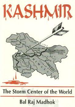
It is clear
from the above account that Jammu & Kashmir State as at present constituted
is the creation of Gulab Singh who welded together such diverse and far-flung
areas as Jammu bordering on the Punjab, Laddakh bordering on Tibet and
Gilgit bordering on Sinkiang, Afghanistan and USSR across the Pamirs.
It is wrong
to describe the British grant of dejure recognition to him as master of
Jammu & Kashmir as a sale deed. He was already in possession of most
of this territory and would have fought for it if the British had tried
to dispossess him. Actually the British had earlier offered him this territory
even without payment of any money. He was forced to pay this money simply
because of his own loyalty to the Lahore Darbar and the chicanery of Lal
Singh.
Some writers
have been very critical of Gulab Singh for not taking part in first Anglo-Sikh
war of 1846 and for making a separate treaty with the British after the
Treaty of Lahore under which the Lahore Darbar ceded the territories that
were already in Gulab Singh's possession and Kashmir valley to the British
in lieu of the war indemnity which it was not in a position to pay. This
criticism is unjustified.
Gulab Singh
cannot be blamed for keeping away from Lahore after the brutal murders
of his brothers and nephew. He too might have met the same fate had he
been in Lahore when Khalsa army went on the rampage. However, he was opposed
to pitched battles with the British and had suggested attack on Delhi.
His advice was not heeded. In the circumstances he could not be faulted
for remaining aloof.
Jammu was his
ancestral home. Other territories including Laddakh and Baltistan had been
conquered by him with his own resources without any help from Lahore Darbar.
As Governor of Peshawar and Commandant of Sikh forces in the first Anglo-Afghan
war he had made his own assessment of the British. Developments in Lahore
after the death of Maharaja Ranjit Singh in 1839 had convinced him that
foreboding of Ranjit Singh that all territory will come under British away
- "sab lal ho jayega" was coming true. Being a realist he decided to salvage
as much of the Lahore kingdom as possible for himself. He was in a strong
position. The British were not in a position to take on his Dogra armies
at that time. They therefore, adopted a realistic course of accepting the
de-facto position and get the indemnity money they needed so badly in the
bargain. Gulab Singh got his de-facto position recognized by the wily British
not by their grace but by pressure of the realities on the ground. Had
he not been able to safeguard his possessions and get dejure recognition
for them, Jammu, Kashmir, Laddakh, and Gilgit would have gone the way of
Punjab and would have become ipso-facto parts of Pakistan in 1947.
It is, therefore,
necessary that an objective assessment of Gulab Singh's achievements be
made in the light of ground realities at that time. He was not only a great
soldier but also a statesman. It is true that he was primarily concerned
with his possessions and his interests. But what he achieved had far reaching
impact on the interests of Hindustan as a whole. His foresight and constructive
statesmanship, therefore, deserve praise and not condemnation.
It is unfortunate
that such writers have failed to give not only Gulab Singh what was his
due but have also failed to give due praise to his general, Wazir Zorawar
Singh, whose military campaigns in Laddakh and Tibet can be compared with
the campaigns of Hannibal and Napolean.
Zorawar Singh
was one of the greatest military captains of the world. His prowess, quality
of leadership and the strategy he adopted in his trans-Himalayan campaigns
must be studied by the military leaders of free India with pride.
The events
of circumstances leading to the creation of Jammu and Kashmir State as
detailed above naturally made it a heterogeneous conglomeration of diverse
and distinct areas devoid of any basic unity, geographical, social or cultural,
except obedience to a common crown. Geographically it presented a delightful
panorama of alluvial plains to the south of Jammu, obtained in return for
the territory lying between the Jhelum and the Indus, melting into hills,
hills melting into snowy mountains and mountains into high arid and wind
swept plateaus of Laddakh and Baltistan with the vale of Kashmir as an
emerald set in the centre inviting the wistful glances of all Asian neighbors.
A Conglomeration
of Six Distinct Regions
Broadly speaking
geography divides this State into the basin and catchment areas of three
major rivers - the Chenab, the Jhelum and the Indus. The entire area from
the Plains of Punjab to Panchal range of the Himalayas is drained by the Chenab. The valley of Kashmir and western districts of
Mazaffarabad, Poonch
and Mirpur form the basin of the Jhelum. The Indus drains the waters of Laddakh, Baltistan and Gilgit before turning south and cutting through
the Himalayas to reach the Punjab plains.
From the linguistic
and cultural point of view, this vast and varied state of 84471 sq. miles,
bigger than many of the modern European States, whose only unity lay in
a uniform and unified administrative system, could be divided into six
distinct regions with distinct identities. A clear understanding of the
historical and cultural background of these different peoples and regions
and a proper appreciation of their economic, social and cultural moorings
and political aspirations is essential for proper understanding and appraisal
of the Kashmir problem.
Jammu
The first and
the foremost part or region is "Dugar" better known as Jammu, the homeland
of the founder of the State, as also of the Dogra people. It is directly
contiguous to East Punjab and Himachal Pradesh in India and includes the
entire districts of Jammu, Kathua, Udhampur including Bhadarwah and Kishtwar
and the eastern parts of the erstwhile districts of Riasi and Mirpur of
the administrative province of Jammu. It stretches from the Ravi in the
east to roughly the cease- fire line in the west and from Suchetgarh in
the south to the Banihal pass in the Pir Panchal range in the north. Its
total area is about 12,000 sq. miles.
The inhabitants
of this region are Dogras. Thousands of Kashmiris have also settled in
the Ramban and Kishtwar areas. The Gujars, who speak a Pahari dialect,
inhabit the western part of Riasi District. The total population of this
region is about 30 Lakhs of which over 20 Lakh are Hindus. The spoken language
of this region is Dogra which includes a number of Pahari dialects and
is written in the Devnagari script.
The whole of
this region is mountainous except for a narrow belt bordering on the Punjab.
A few beautiful valleys like that of Bhadarwah, which is known as "miniature
Kashmir," lie in its interior. The Chenab flows right through this region
draining its waters and carrying its valuable timber wealth to Akhnur near
Jammu before it enters the Punjab state of Pakistan. The chief occupations
of its people are agriculture and soldiering. Thousands of hardy Dogras
from this region serve in the Indian army. Maize and rice are the main
agricultural crops. Lower Himalayan ranges traversing this region are covered
with rich fir and deodar forests. Lumbering, therefore, is an important
industry. Forest produce, lime, resin, honey, 'Rnardana' and medical herbs
besides timber form the chief exports of this area. It is also the richest
part of the state in respect of mineral wealth. Extensive deposits of coal,
mica, iron and aluminium are known to exist in it.
Bhadarwah,
which is now linked up with Chamba in the Himachal Pradesh and with Batote
on the Jammu- Srinagar highway by motorable roads, is perhaps the most
beautiful part of this region. Its fruits are superior even to those of
Kashmir Valley and the natural scenery is no less charming. Kishtwar, which
lies just to the north of Bhadarwah, is famous like Kashmir for its saffron
fields. It forms a direct link between Dugar and Laddakh which lies to
its north.
Politically,
this area had remained divided into a number of small principalities ruled
over by Hindu Rajas owing occasional and doubtful aIlegiance to the powerful
empires rising in the plains till their unification into one compact whole
by Raja Gulab Singh. Jammu is the chief town of this region and the winter
capital of the whole state.
Socially, culturally,
and economically the people of this region are indissolubly linked with
the Dogras of East Punjab. In fact, the Dogra belt spread over Gurdaspur,
and Hoshiarpur districts of East Punjab, Kangra, Chamba and Mandi districts
of Himachal Pradesh, and the Dugar zone of the Jammu and Kashmir State
forms a compact homeland of the Dogras. Naturally, therefore, the people
of this region aspire to remain connected with India, irrespective of what
happens to other parts of the State.
From the Indian
point of view this is the most important part of Jammu and Kashmir State.
It forms the only direct and feasible link between India and the rest of
the State. The Pathankot-Jammu road and the Jammu- Banihal road that connect
the rest of India with the Kashmir Valley pass entirely through this region.
The choice of its inhabitants on the question of accession is beyond doubt.
Its mineral and power resources are immense.
Laddakh
To the north-east
of Dugar lies the extensive plateau of Laddakh. It is directly contiguous
to Himachal Pradesh. It was being ruled over a local Buddhist Raja, Tradup
Namgyal, when it was conquered by Wazir Zorawar Singh between 1834 and
1840 for his master Maharaja Gulab Singh. He entered Laddakh through Kishtwar
in Dugar and not through Kashmir. Its total area is about 32,000 square
miles and total population is about two lakhs, majority of which are Buddhists.
This is a very
backward area. The inhabitants eke out a bare existence by rearing yaks
and cultivating 'Girm," a kind of barley, in the few high and dry valleys
of the Indus. Their chief pre-occupation is their religion. They give their
best in men and material to the numerous monasteries that act as an oasis
in a veritable desert. The wealth, art and learning of the people is Concentrated
in these monasteries. Some of them Contain rich collections of ancient
Buddhist literature in Sanskrit or its translations in Tibetan. The population
is kept down by social customs like polyandry and dedication of girls and
boys to the monasteries and is being further reduced by slow conversion
to Islam through inter-marriages with Balti and Kashmiri Muslims. The offspring
of these mixed marriages are known as "Arghuns." They form the trading
community.
Leh, the chief
town of this region, situated on the Indus at a height of more than 11,000
feet above sea level is one of the highest habitats in the world. It used
to be the seat of the Raja of Laddakh before the Dogra conquest. After
the conquest and formation of Laddakh district, it became the summer headquarters
of the District Officer appointed by the State Government. It is now connected
with Srinagar by a well-kept highway. It crosses the high mountains dividing
Laddakh from Kashmir through the Yojila pass. Leh used to be, till a few
decades back, a great mart for Central Asian trade. Caravans laden with
silks, rugs and tea used to pour into Leh frorn distant Tashkand, Kashghar
and Yarkand. These goods were exchanged here for sugar, cloth and other
general merchandise from India. But since the absorption of these Central
Asian states into empires of Russia and China, this trade has virtually
stopped. But the strategic importance of Leh as a connecting link with
Central Asia rernains.
A part of Ladakh
was over-run by the Pakistanis in 1947- 48, when, after capturing Askardu
and Kargil, they began their advance on Leh. Several hundred innocent Buddhists
were murdered and many monasteries were looted, despoiled and desecrated
by the invaders. But the epoch - making landings of the I.A.F. Dakotas
carrying the sinews of war on the improvised airfield of Leh at more than
11,000 feet above sea level and the brilliant winter offensive of the Indian
army leading to the capture of the Yojila Puss and Kargil saved Leh and
the rest of Laddakh from going the way of Gilgit and Baltistan.
Baltistan
The third distinct
region of the State is Baltistan inhabited by the Balti people. It lies
to the north of Kashmir and west of Laddakh. For administrative purposes,
it was grouped with Laddakh to form the district of that name. Its total
area is about 14,000 square miles and total population about 1,30,000 according
to the 1941 census. Almost all of them are Muslims by religion.
Baltistan was
conquered by Wazir Zorawar Singh along with Laddakh between 1834 und 1840.
Before that it was being ruled over by petty Muslim Rajas of Laddakhi descent.
The chief town of this region is Askardu which used to be the winter headquarters
of the Laddakh district. Situated on the Indus like Leh, it has a fort
of great natural strength.
Baltistan was
overrun by Pakistani troops and Gilgit Scouts during the winter of 1947-48.
The State garrison in the Askardu fort held on gallantly for some months.
But no effective help could be sent to them from Kashmir because the Yojila
pass had passed into the control of Pakistan and aid by air was made difficult
by the enemy occupation of all possible airstrips.
The winter
offensive of the Indian Army in 1948 succeeded in the recapture of the
Yogila Pass and the town of Kargil beyond it, which commands the road to
Leh and Askardu. Thus a part of Baltistan came back into Indian hands but
its major portion including the town of Askardu still lies on the Pakistan
side of the cease- fire line.
Balistan is
not of much economic or strategic importance. It is sandwiched between
Laddakh and Gilgit. But it has provided Pakistan with a convenient route
for advance toward Yojila Pass and Leh from its base in Gilgit. Its main
produce are barley and fruits especially apricots. Some of the valleys
of tributaries of the Indus in this zone are quite fertile. The people
of this part of the State are very backward and till the time of Pak invasion
of 1947, were quite indifferent to political developments in Kashmir and
Jammu. But now they have been infected by Pakistani propaganda. Pakistan
is known to have linked Askardu with Gilgit by a motorable road and has
also built a big air base there. It is now the base of supply for Pak troops
on the Siachin Glacier.
Gilgit
The fourth
distinct region of the State is Gilgit. It includes the Gilgit district
and feudatory states of Hunza, Nagar, Chillas, Punial, Ishkuman, Kuh and Ghizar. The total area of this region is about 16,000 square miles and
the total population in 1941 was about 1,16,000. Almost all of them are
shia Muslims. Most of them are followers of the Agha Khan. They belong
to the Dardic race and are closely connected with the Chitralis in race,
culture and language. Shina and Chitrali are the two languages spoken by
them.
This region
was conquered with great difficulty by Maharaja Gulab Singh and his son
Maharaja Ranbir Singh between 1846 and 1860. Thousands of Dogra soldiers
lost their lives in the campaign that led to the conquest of this inhospitable
but strategically very important region. It is here that the three Empires,
British, Chinese and Russian met. The independent Kingdom of Afghanistan
also touches its boundaries.
The strategic
importance of this region increased very much after the advent of air force
and the expansion of the USSR and Communist China towards the Central Asian
regions adjoining Gilgit and Baltistan. This region contains the fertile
valley of the Gilgit river, a tributary of the Indus. The name of the entire
region is derived from the name of this river.
Gilgit is divided
from Kashmir by the same Himalayan range which divides Kashmir from Laddakh
and Baltistan. But the direct and the shortest link between Gilgit and
Kashmir is provided by another Pass, the Burzila. It is more than 13,000
feet about sea level and, therefore, remains closed for many months in
the year. The access to Gilgit from Pakistan via Peshawar is comparatively
easy.
The whole of
Gilgit including the Burzila Pass now lies on the Pakistan side of the
cease fire line. The state garrison as also the military governor appointed
by the State were over-powered by Pakistani troops with the aid of the
local militia, the Gilgit Scouts, during the winter of 1947. Gilgit has
since been developed as a major military base by Pakistan.
From the economic
point of view Gilgit is not rich though it has vast potentialities. Its
climate is bracing and temperate. Temperate fruits like apple, apricot,
and almonds grow in abundance. "Zira", (or cumin), a valuable spice, however,
is the most valuable produce of this area and is exported in large quantities.
The people are healthy and fair-colored. Polo is their national game in
which they excel. They had come under Hindu and Buddhist cultural influence
quite early. Gilgit probably formed a part of the Khotan Province in Ashoka's
empire. A recent find of Buddhist and Sanskrit books near Gilgit confirms
this view. A class of people among them is held in high esteem. They are
expected not to eat beef and to remain clean. They were perhaps the Gilgiti
Brahmins before their conversion to Islam.
Till 1947,
these people were very much devoted to the Maharaja and his Government.
They protested against the lease of Gilgit to the British. But after the
partition, they, especially the Rajas of Munza and Nagar, were incited
by the Pakistanis and the British Political Agent to press the Maharaja
for accession to Pakistan. They later became collaborators of the Pakistanis
and revolted against the Maharaja's government.
Punjabi
Speaking Belt
The Punjabi
speaking districts of Mirpur, Poonch and Mazaffarabad lying along the river
Jhelum which forms the western boundary of the State, constitute the fifth
district region of the State. Mirpur formed a part of the Jammu province,
Muzaffarabad of Kashmir and Poonch was a big "Jagir" ruled over by a descendant
of Raja Dhian Singh, younger brother of Gulab Singh, who rose to be the
Prime Minister of Maharaja Ranjit Singh. The total area of this belt is
about 6,000 square miles and total population about 11 lakh. Nearly a lakh
of them were Hindus. They have been either killed or squeezed out by the
local Muslims with the help of Pakistani invaders. The chief towns of this
area are Mirpur, Poonch, which is still in Indian hands, and Muzaffarabad
on the confluence of the Jhelum and the Krishna Ganga. This last town is
now the headquarters of the so-called "Azad Kashmir" government. Mirpur
and Poonch were conquered by Gulab Singh for Maharaja Ranjit Singh from
the loca Muslim Rajas. Muzaffarabad was acquired by him after he had occupied
Kashmir by defeating its Muslim Sultan in a bloody battle.
Parts of this
region are quite fertile. But the real importance of this region lies in
its warlike manpower. Poonch area alone gave about sixty thousand recruits
to the Indian army during the Second World War. The Sudhans, the Jarals
and the Chibs who inhabit this area are Rajput converts to Islam. This
area has an additional importance for Pakistan because the river Jhelum
which carries the rich timber wealth of Kashmir and Karen forests flows
through it. The headworks of the Upper Jhelum Canal at Mangla are situated
near Mirpur in this zone. This region also links the West Punjab and the
North-Western Frontier Province with the valley of Kashmir.
The people
of this region are bound in bonds of common religion with those of Hazara,
Rawalpindi and Jhelum districts of West Punjab. They actively sided with
the Pakistani raiders when the latter invaded the State from that side.
At present most of this region, except the towns of Poonch and Mendhar,
lies on the Pakistan side of the cease-fire line which runs just three
miles from the town of Poonch.
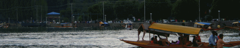
Kashmir
Valley
In the centre
of the State, surrounded by the diverse regions and peoples mentioned above
and cut off from them by high Himalayan walls, lies the beautiful valley
of Kashmir, the 'Nandan Vana' of India.
These geographical,
and linguistic regions of the State provide the geo-political background
of the Kashmir problem. The attitude of the people inhabiting these distinct
regions toward the partition of India and the developments that have taken
place since then, have their roots in hundred years of Dogra rule over
this vast and heterogenous state. A peep into these hundred years is therefore
necessary for proper understanding of the genesis of Kashmir problem.
FOOTNOTE
2. Making of
Kashmir State by K. M. Panikkar: pg. 98.
|